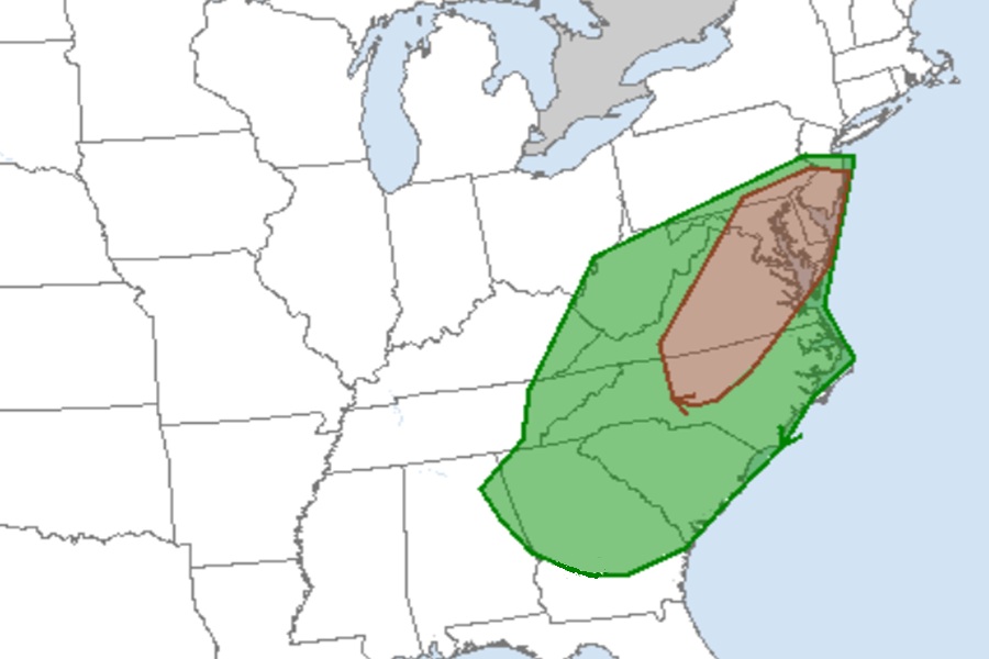
Today’s risk of tornadoes has increased across portions of New Jersey, Delaware, Maryland, Virginia, and North Carolina. This assessment is based on a new Convective Outlook update issued by the National Weather Service’s Storm Prediction Center (SPC) which has identified an enhanced threat of tornadic thunderstorms across the Mid Atlantic today into this evening. This tornado threat is part of a severe weather event unfolding across the eastern U.S. today.
The greatest threat of tornadic thunderstorms today is from the southern half of New Jersey into southeastern Pennsylvania, including the city of Philadelphia, all of Delaware, much of Maryland, the middle 2/3rds of Virginia, and north-central North Carolina.
According to the SPC, scattered to numerous severe storms are possible this afternoon and evening, with 55-70 mph gusts capable of wind damage extending from the Mid-Atlantic states into the Southeast. The potential for a few tornadoes exists from the Mid-Atlantic states into the Carolinas.
For now, water-vapor imagery on satellite photography shows a potent mid- to upper-level trough over the Ohio and Tennessee Valleys; this feature is forecast to move into the Mid-Atlantic states and the Carolinas by late evening. In response to this shortwave trough, a deepening surface cyclone will move from the Kentucky/West Virginia border east-northeastward along a quasi-stationary front into southeast Pennsylvania / New Jersey by evening; a trailing cold front from this cyclone will move across parts of the Southeast, Carolinas, and Virginia.
As large-scale ascent with the approaching shortwave trough develops across the warm sector, thunderstorms are expected to develop along and near the cold front. A mix of cells and linear bands will gradually evolve into broken band convective structures with time as storms move east. Atmospheric dynamics will favor strong to severe wind gusts. Damaging winds of around 55-70 mph are expected to be the primary severe hazard, although a tornado threat will exist primarily with bowing segments.
Farther north, the northern extent of a destabilizing warm sector immediately ahead of the deepening surface low, will favor an increasing severe weather risk this afternoon. Scattered storm development is initially forecast near the higher terrain with additional cellular development expected in the northern Virginia to southeastern Pennsylvania corridor late this afternoon and especially into the evening.
“Given the moist low levels and favorably shaped hodographs in proximity to the surface low, (we) have enlarged 5-percent tornado probabilities for a supercell-tornado risk,” warned the SPC. They added, “Some consideration for higher tornado probabilities was given, but confidence was too low at this time. Damaging gusts and large hail are also possible with the stronger storms.”
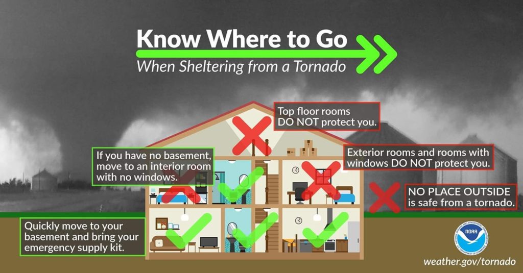
Due to this growing threat, the Storm Prediction Center has begun to issue Tornado Watches. A Tornado Watch means that conditions are favorable for tornadoes and severe thunderstorms to develop in the watch area. It’s a heads-up to be aware of potential severe weather, monitor weather updates, and be prepared to take action if a warning is issued. While a watch indicates a possibility of tornadoes, it doesn’t mean they are guaranteed to occur.
When a Tornado Warning is issued, this means an actual tornado has been observed by trained spotters or local officials or has been identified by weather RADAR. Tornado Warnings are usually issued on a county-by-county basis and people in a county where a Tornado Warning is issued may only have seconds or minutes to get to safe shelter from the tornado that is on the ground.